Tuesday, April 1, 2008

Day 112-116 - 27-31 March

We left the Herb River Anchorage in time to arrive at the Ladies Island Bridge after the morning rush hour...yes, under certain circumstances, the rush hour still has a negative impact on retired folks. However, we don't mind the impact since the traffic delays that occur when we ask a bridge to open for us probably are worse than the inconvenience of having to wait for the rush hour to be over...after all, we don't have a schedule to keep!

We try to do our part by contacting the bridge tender just before we arrive so he or she knows we are arriving. Normally, the bridge tenders work closely with us to time the opening just as we are about to go into a panic as we approach the bridge. Some bridges are slow to open due to the mechanical design and these are particularly interesting since we have to adjust our speed...sometimes when the current is pushing us toward the bridge...to make certain we have enough clearance for our mast to get past the steel and concrete without causing anything to hit and result in metal fragments dropping onto the deck. So far...so good!

As soon as we are clear, we call the bridge tender to let him/her know just about the same time as the horn sounds announcing the bridge is closing right behind us. The sequence is something like this...

"Ladies Island Bridge...Ladies Island Bridge, this is the northbound sailing vessel Windreka." To which the bridge tender responds, "Vessel calling the Ladies Island Bridge, this is the Ladies Island Bridge." To which we respond, "Ladies Island Bridge, this is Windreka...request an opening at your convenience." To which the bridge tender responds, "Windreka, I will open the bridge as soon as you get close...keep coming." To which we respond, "Roger...we will keep approaching."

The next thing that usually happens is a bell or horn on the bridge will sound and shortly afterwards the traffic control gates will drop, stopping traffic. Shortly after that, the bridge will begin to slowly open for our passage and we will put the boat into high gear to time our arrival and passage when the bridge is fully open. All this sounds very easy, but imagine several boats competing for space in a narrow channel all waiting for the bridge to open. Imagine also a bunch of other boats on the opposite side of the bridge waiting to come through too. The rule is the boats being pushed through with the current have the right of way, but not everyone knows and observes this rule. Imagine also, powerboats trying to get through ahead of the sailboats because they will pass them anyway after they get through the bridge. Imagine also a few small powerboats that can get under the bridge without waiting for it to open and trying to work their way through the flock of boats waiting on either side. Imagine all this and you have some idea of what happens when we have to request a bridge to open for us.

Sometimes interesting things can happen. For example, a bridge tender may reply, "Windreka, there is a little old man in a wheelchair trying to cross the bridge and I can't ask him to hurry. I'll have to wait until he gets to the opposite side before I can open the bridge." To which we can only respond, "Ladies Island Bridge, Windreka is standing by," while we both wait for the senior citizen to make his way safely across the bridge.

Just before we arrived at the bridge this morning, the wind piped up and increased in velocity as we approached Parrot Creek leading into the Morgan River. The wind was really blowing and the waves were crashing over the deck as we approached the turn toward the marina. In addition it was blowing from the south and would be pushing us away from the dock as we approached.

We contacted Dataw Island Marina to let them know we would be arriving about the time they would normally be closing operations for the day. We offered to anchor near the marina and come in the next morning, but they insisted we should come to the dock and they would meet us to take our lines. With the assistance of Ben and Willie, the marina dock crew, and friends Frank and Debbie, we arrived and secured our lines on the marina face dock for the night. We planned to top off our fuel tanks and move into our slip the next morning when the tidal currents were slack and the wind lighter.

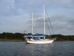
After 112 days our first long distance cruising adventure was at an end and all that remained was to square Windreka away for a month or so and return home to face the IRS and our groundwater drainage challenges. The easy part was over and we have a lot of memories and stories to share with friends and neighbors.

In between cleaning and squaring Windreka away, we did take some time to relax with our friends who live at Dataw Island. Joe and Frank and Frank's grandson, Michael took an afternoon to explore a couple of the nearby creeks off the Morgan River. We found a couple of likely locations for Frank to explore on his search for the ultimate shark's tooth and we found the back side of the island where the US Government keeps monkeys that are used in research.

We celebrated Sarah's birthday at the Johnson Creek restaurant with friends Frank and Adam and the next day we celebrated again by doing seven loads of laundry.

On Monday, we had a real treat. The Spirit of South Carolina arrived to spend the next ten days at Dataw Island. The Spirit is a training vessel designed as a replica of a pilot schooner and roughly the same size as the Pride of Baltimore II...although the Pride is designed as a replica of a Baltimore Clipper. Read more about the Spirit at: http://www.scmaritime.org/. And while you're at it, read more about the Pride at: http://www.pride2.org/.

We will leave Windreka in Beaufort in the able hands of the Dataw Island Marina staff and start our trip home on 1 April. Actually, there is a lot more going on than stated in this last sentence and if you check back, you may read more about it!

Day 111 - 26 March

We awoke to a light breeze from the NNE and decided it was time to move further north. We cast off our lines and left Jekyll Harbor Marina bound for the dreaded Georgia skinny water on the ICW. To our surprise and probably due to leaving with the rising tide, we had absolutely no difficulty finding more than enough water beneath Windreka's keel to keep us afloat with room to spare. We had a pleasant day cruising through the isolated ICW creeks and channels and only met a handful of other boats during the day.

We arrived at the same New Teakettle Creek anchorage we stopped at on our way south. It was a pleasant place then and this time we had the anchorage to ourselves...just the way we like it. It was early in the afternoon and it was pleasantly warm, so we watched the pelicans fishing for their dinner before we went below to prepare our own dinner.


Sunday, March 30, 2008

Day 108-110 - 23-25 March

We were conflicted about how to handle the next leg of our cruise. We had heard lots of recent complaints and reports about the shallow water in Georgia. The U.S. Army Corps of Engineers Georgia budget for keeping the ICW open and dredged was underfunded this year and little work was done to keep the ICW channel open through some of the "skinniest" water of the ICW. The weather forecast wasn't ideal but wasn't too discouraging, so we decided to take the outside route and headed out for the Atlantic along St. Mary's inlet. The inlet is a long one and we rolled in the 2-4 foot swells for almost five miles before we could head north. When we finally headed north we found we were pitching continually in the rolling waves and facing a counter current that combined to reduce our forward speed to less than 2 nautical miles per hour. After a few minutes we realized we had made a mistake and headed back toward the inlet, back into the channel, and back to the ICW.

We passed the south end of Cumberland Island about three hours after we had departed and continued past the Naval Submarine Base Kings Bay under the watchful eyes of the Homeland Security patrol boat. Kings Bay is one of the homeports of the US Navy Trident submarine fleet which are the platforms for the nuclear sea launched ballistic missile and sea launched cruise missile weapon systems.


We arrived at the Jekyll Harbor Marina in the late afternoon and took a berth along the north end of the large face dock where we spent the next two nights. At least the adverse weather each day ended in a spectacular sunset.


The following day Joe walked along the bike paths on the south end of Jekyll Island to enjoy the scenery and look for the "Glory Dock" where the final battle scenes of the movie Glory were shot. It was a cool day and the wind continued blowing from the north so we remained at the Jekyll Harbor Marina for another day to let the wind diminish and shift around to the south. At least we got to sample a little of the scenery of another picturesque Georgia barrier island.

Friday, March 28, 2008

Day 106-107 - 21-22 March

One of the more interesting areas we visited was Cumberland Island. We anchored off the Sea Camp Dock on the east side both on the way south and again on the way north. The island, one of Georgia's barrier islands, is over 17 miles long, with an area of 36,415 acres, including marsh mudflats and tidal creeks. Most of Cumberland Island is part of the National Seashore. The National Park Service limits how many people can be on the island at any one time. The island has three major ecosystem regions. Along the western edge of the island are large areas of saltwater marshes. Live oak trees covered with Spanish moss and palmetto plants live at the edge of Cumberland's dense maritime forest. Cumberland Island's most famous ecosystem is its beach, which stretches from Long Point on the north to the southern tip. Along this long stretch of white sand, one may see wild horses, birds, and other wildlife. This area is also a nesting area for loggerhead sea turtles.

We anchored on the west side of the island near Sea Camp Dock, one of the two docks where ferry boats tie up twice daily and cruisers can tie up their dinghies while exploring the National Seashore. We joined a guided tour led by Rene a lively and entertaining National Park Service ranger who met the ferry boat and took the group of us on a tour of the southern part of the island. Along the way, we found a number of small fossilized sharks teeth. The little fellow on the left upstaged Rene at one point of her narration and the group got up to get a closer look at him/her. Until today, Sarah who is from Texas and real armadillo country had never seen one of these little armored creatures alive and in its natural habitat. Apparently there are lots of has-been armadillos to be found in Texas along the side of the highways there.

Afterwards we took off on our own to explore the island. From the Sea Camp Dock we walked south to the ruins of an old mansion that once belonged to the wealthy owners of the island. Then over a boardwalk from the live oak forests to the dunes and beach of the east side of the island facing the Atlantic.


We turned north again along the beach to head back for the path through the dunes and live oak forest to Sea Camp Dock where we started. Along the beach we saw birds and a small herd of wild horses. According to the latest census this month there are about 124 wild horses on Cumberland Island and we saw small herds as we came up the river, as we were walking along the beach and south of Sea Camp Dock while we were back on Windreka at anchor. We found the pole marking the boardwalk from the beach to Sea Camp Dock and headed back west past the campgrounds and toward the Sea Camp Dock and our anchorage. We met several interesting people as we walked along the island. We ended up resting on the porch of the Sea Camp cabin with some fellow cruisers, Frank and Terry. After a short rest, we climbed back into our dinghy and returned to our boat to get ready for the next leg of our cruise.

Friday, March 21, 2008

Day 105 - 20 March

We went to sleep with the wind howling and gusting and Windreka rocking and rolling in our slip at the St. Augustine City Marina. We woke up again at 4:30 AM to a heavy rain. After shutting ports and hatches and side curtains, we went back to sleep and woke up once again at sunrise to overcast skies and cool weather. After a quick breakfast, the sun came out and we put on our jackets and headed "downtown." As we do any place the Old Town Trolley runs, we signed up to take the tour and take advantage of the ability to get on or off the trolley at any of their stops. All the sights we wanted to see were included on the tour and since we allowed ourself only one day to "do the town," we had our plan and we executed.

One of the major stops was the Castillo de San Marcos where we walked around this historic US National Park. The Castillo is a Spanish built fort located in St. Augustine. It was known as Fort Marion from 1821 until 1942, and Fort St. Mark from 1763 until 1784 while under British control. The Castillo is a masonry star fort made of a stone called "coquina", literally "little shells", made of ancient shells that have bonded together to form a type of stone similar to limestone. Workers were brought in from Cuba to construct the fort and the coquina was quarried from Anastasia Island across the bay from the Castillo, and ferried across to the construction site. Construction lasted twenty-three years, being completed in 1695. For a detailed history of the Castillo, look at http://en.wikipedia.org/wiki/Castillo_de_San_Marcos.


Flagler College and Hotel


St. Augustine Lighthouse and the 219 steos to the top not climbed!


Mission Nombre de Dios is the location where the first Catholic Mass was said in the United States. The mission was one of the first Spanish missions to the Indians of Florida and was established soon after the founding of St. Augustine in 1565. Due to the hostility of the Indians, the Jesuits withdrew from the mission in 1572. In 1573 the Franciscans began missionary work along the Atlantic coast. The mission system collapsed at the beginning of the 18th century after raids by soldiers and their Indian allies.

Lynn Hershfeld and Coyote, Gulfstar 50

Etc.

Wednesday, March 19, 2008

Day 104 - 19 March

The bascule bridge just north of the Daytona Beach anchorage has restricted opening hours during the morning and evening rush hours. So we planned on arriving at the bridge just after the morning rush hour restrictions ended. The wind was at our backs though it was a bit lighte most of the day. Nevertheless, it was another rolling, struggling with the helm day...so much for following seas and winds at your back!

We arrived at the St. Augustine City Marina fuel dock to top off and established another personal best...diesel fuel at $4.10 per gallon! It just keeps going higher and higher. The fuel dock attendant told us that the price was $3.74 per gallon a week ago and the cost has gone up each day...just like the gas stations back home! One of our favorite web sites (http://www.cruisersnet.net/index.php) is attempting to track and advise boaters about the price of fuel and the location of fuel docks offering diesel and lower prices, but with the volatility of the fuel prices this will be difficult to do.

The City Marina is a bit pricey, but we are impressed with the courtesy and professionalism of the dock staff and the facilities are excellent. We were met at the fuel dock by Mike and Jim who helped us with our lines as we struggled with the wind, current and unfamiliar facility. After topping off, registering and paying our bill, we were assisted by Mike and Jim with our departure from the fuel dock and our arrival around the corner at our slip. We can't say enough in admiration of the way we were welcomed and with the extra effort that was made to ensure we were securely and properly tied up at the dock, our electrical lines connected, our cable TV connection was made, and a welcome mat laid out...yes, a welcome mat! It may be pricey but we certainly got royal treatment.

We made a run on the marina store to pick up some touring information to plan our time tomorrow. In the morning, we'll take the Trolley Tour (http://www.trolleytours.com/) to scope out the historical sites and in the afternoon, we'll stop at the ones we like best.

St. Augustine...the nation's oldest city...holds the distinction of being one of the nation's most charming. St. Augustine was founded forty-two years before the English colony at Jamestown, Virginia, and fifty-five years before the Pilgrims landed on Plymouth Rock in Massachusetts - making it the oldest permanent European settlement on the North American continent. Read more about St. Augustine at: http://www.oldcity.com/.

Day 103 - 18 March

We planned to anchor in Rock House Creek where we stopped on the way down to the Keys. But we were making such good time and we want to get to St. Augustine tomorrow, so we decided to stop at Daytona Beach at a new anchorage north of the city. The Anchorage was a bit exposed, but the holding was excellent according to Skipper Bob and he was right. The anchor came up in the morning with glue-like mud stuck to it. It took an extra effort to hose all the mud off as Joe was hauling it in...no danger of dragging even with the gusty winds from the south!

The route from Cocoa to Daytona isn't one of our favorites. It consists of long, straight, narrow, shallow channels through wide expanses of water...the Indian River, Mosquito Lagoon and Banana River. Also, the wind and waves were on our stern which made it a rolling trip struggling with the helm all the way.

Other than the opportunity to see a lot of birds, dolphin, manatees, etc., the only interesting part of the trip is passing by the Patrick Air Force Base and the Kennedy Space Center where all of our space history is centered. The Space Shuttle Vehicle Assembly Building can be seen for miles and is an impressive sight not only from a distance but from Joe's recollection of a tour of the Space Center several years ago.

We missed the shuttle launch of STS 123 last week and we hoped to catch a glimpse of the military GPS payload which was launched on Saturday. But Miami was too far south...although Joe thinks he saw the booster rocket separation...for the shuttle launch and it was too cloudy for us to see the military payload launch from Cocoa early Saturday morning. It would surely have been an impressive sight to see either of the night launches.


Just north of the Space Center is the Haulover Canal which is a historic channel between the Indian River to the west and the Mosquito Lagoon to the east and is just north of Merritt Island. The Canal is also part of the Canaveral National Seashore. Read about them at: http://en.wikipedia.org/wiki/Canaveral_National_Seashore and http://en.wikipedia.org/wiki/Old_Haulover_Canal.
Manatees are everywhere in Central Florida. This one was in the water in the Haulover Canal. They still look like floating logs and have to be protected by a set of power boat speed management measures. Sailboats are slow enough that they pose small danger to manatees and most wounding or killing appears to be from strikes from fast moving power boats. In fact we kept a close watch for manatees, but all we saw were dolphin.


Just offshore of Central and Northern Florida and Georgia are the Right Whale feeding, calving and migration habitat between 1 December and 31 March. We are keeping a close lookout when we are on the Atlantic. However, there are only an estimated 350 Right Whales left in the Atlantic. They are a rare sight and it's illegal to approach closer than 500 yards.

Monday, March 17, 2008

Day 102 - 17 March


We woke up to the sound of someone behind the boat making a lot of noise and obviously not trying to be quiet or respectful of anyone's privacy...then we remembered we were in Florida. There was dredging going on...as previously mentioned, we did touch bottom coming in to the marina. However, it was a bit annoying to find the dredging contractor parking his equipment within inches of Windreka's stern and dinghy without even the courtesy of telling us they would be working next to us. The operator of the work platform in the photos walked by our boat a half dozen times during the day without speaking to us.

The east winds today were still higher...gusts over 25 knots...and the intracoastal waterway chop was choppier than our relaxed cruising comfort factor allows. So we decided to lay over another day and go back to look at the historic Cocoa Village near the marina.

We spent a relaxing morning reading and relaxing on Windreka and a nice afternoon walking around the shops in Cocoa Village (http://www.cocoavillage.com/). The little fellow on the right came out to welcome us and decided to visit for a few minutes. Among other things, we discovered the Village Ice Cream and Sandwich Shop (http://www.cocoavillage.com/directory/listing/index.html?id=893id=893) and Joe found a real hardware store (Travis Hardware...http://www.cocoavillage.com/directory/hardware/). It's always reassuring to know that there are still real hardware stores in existence and there are alternatives to Home Depot and Lowes! Wonder of wonders...we were welcomed, asked once if we needed any assistance or were looking for anything specific, invited to look around on both floors, and never once treated as if we were shoplifters.


Now here's a historic character!

After our trip "downtown" we returned to Windreka to get ready to depart in the morning. We can probably count on the dredging crew to wake us up and we have to make our way out of the marina before we are blocked in by them. Hopefully, the wind will start to clock around to the southeast a bit to reduce the chop and rolling motion of the waves.